Bill has been wanting to see Dry Falls for awhile now. We flew over it several years ago on the way back home from Chelan but it didn't mean much to me viewing it from the air when I hadn't seen it on the ground and learned more about it. When my software go-live at work was delayed, I decided to take the two days off that I had had approved for vacation off after all. And we flew out to Moses Lake so that we could see Dry Falls and Grand Coulee Dam.
Before we left Pearson, I saw six F-15's taking off from Portland Airport. Seeing them take off always makes me smile. We had a good flight going to Moses Lake. Some of the things we saw were the usual--the Cascade mountains, Bonneville Dam, etc. I enjoyed snapping pictures as we went. One of the more fascinating pictures I took was of Pothole Reservoir near Moses Lake. We had never seen that before and from the air you could actually see into the various potholes in the water. I also saw some big white birds flying over the water there. Not sure if they were some sort of heron or crane. I suspect maybe sandhill cranes as they do have some at a nearby wildlife refuge. And after we landed there, we saw some C17's making approaches into the airport. McChord AFB uses it as a training airport. So it was pretty impressive to see them flying over the runway.


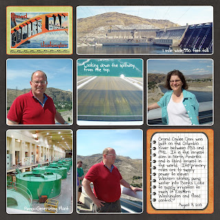
After we landed, we drove to Grand Coulee Dam first to see if we could get a tour. It was a nice tour--mostly just seeing the Pump-Generating Room which pumps water into nearby Banks Lake to be used as irrigation for much of Eastern Washington. But the plant looks much like that of the power plants as well. We drove across the whole dam in our tour bus. It is about a mile wide and 550 feet tall. It is the biggest dam in North America and the third biggest dam in the world so it is quite impressive. It supplies power to eleven western states. We got to stop and take pictures over the spillway and look over the edge.
On the way back to Moses Lake, we stopped at Dry Falls. It too is an impressive location. It is believed to be the biggest waterfalls in the world at about 3.5 miles wide and 400 feet high. That makes it ten times larger than Niagara Falls.
Geologists believe that the landscape of this whole area was shaped by massive flooding during the Ice Age when Lake Missoula's ice dams gave way and water came rushing through this area at 65 miles an hour-forming the great coulees, potholes, and lakes in the area and leaving errant boulders all over the landscape from far away places. During these floods, Dry Falls would have been an actual waterfalls. Even though it was a little bit out of the way, I asked Bill to fly us to Dry Falls before we headed for home. I wanted to see it from the air again now that it had more meaning for me. All I can say is WOW.

A few more pictures of evidence of this flooding both on the ground and from the air. Between Grand Coulee and Dry Falls, there is a huge rock formation called Steamboat Rock. A geologist labeled these lands as the Channeled Scablands and you can really see what he meant by that from the air and on the ground. I was fascinating by the boulders in fields along the road--left by the flood waters as they came through that area.
We had a great couple of days flying and exploring Eastern Washington and learning more about the geology and Ice Age history of that region.


No comments:
Post a Comment